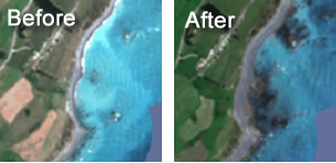
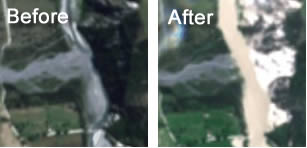
About the data
The imagery used on this site comes from the European Space Agency’s Copernicus Programme. Copernicus’ six Sentinel satellites collect comprehensive pictures of our land, ocean, emergency response, atmosphere, security and climate change to understand the health of our planet.
Sentinel-2 is a wide-swath, high-resolution, multi-spectral imaging mission. Its optical instrument samples in 13 spectral bands: four bands at 10 metres, six bands at 20 metres and three bands at 60 metres spatial resolution. The imagery you see on this site is derived from the four bands with a spatial resolution of 10m.
- Imagery Copernicus Sentinel data 2017.
- Base map contains data sourced from LINZ. Crown Copyright Reserved.
This site is brought to you by the Informatics Team at Landcare Research.
For more information about this site please contact David Pairman (PairmanD@landcareresearch.co.nz).
Terms of Use
The content of this site excluding the maps and imagery are licensed under a Creative Commons Attribution 3.0 New Zealand License (CC BY 3.0).
The maps and imagery available on this site from a number of sources. The information may not be complete, correct or up to date. Landcare Research shall not be liable for any damages, losses, liabilities, costs or expenses arising from any use whatsoever of any material on this website.
Landcare Research reserves the right to modify, suspend or terminate the website for any reason without notice at any time.
23rd February 2017